Location: Mauritius is situated just above the Tropic of Capricorn, in the South West of the Indian Ocean, some 2000 kilometers off the east coast of Africa, between latitudes 19° 60 and 20°32 South and longitudes 57°18 and 57°46 East.
Surface Area: 1,860 sq km
Central plateau rises 600 meters above sea level.
Highest mountain peak: Piton de la Petite Rivière Noire (827 meters)
The total land area of the country is 2040 km2. The Republic of Mauritius also incorporates the island of Rodriguez, situated some 560 kilometers to the east and is 104 km2 in area, the Agaléga situated some 1,000 km to the north of Mauritius and Saint Brandon situated some 430 km to the north-east of Mauritius, both with total land area of 71.2 km2. Mauritius claim sovereignty over Tromelin islands, small islands that lie 430 km to the northeast of Mauritius. The nation’s exclusive economic zone (EEZ) covers about 1.2 million square kilometers of the Indian Ocean. Four fishing banks fall within EEZ limits, the Soudan Banks (including East Soudan Bank), Nazareth Bank, Saya de Malha Bank, Hawkins Bank. In 2011 the United Nations endorsed the joint submission of Mauritius and Seychelles to extend their continental shelf of 396,000 km2 in the Mascarene region which gives the two countries sovereign right to jointly manage and exploit the seabed and subsoil of the joint area.
The island of Mauritius is relatively young geologically, having been created by volcanic activity some 8 million years ago. Together with Saint Brandon, Réunion and Rodriguez, the island is part of the Mascarene Islands. These islands have emerged from the abysses as a result of gigantic underwater volcanic eruptions that happened thousands of kilometers to the east of the continental block made up by Africa and Madagascar. They are no longer volcanically active and the hotspot now rests under Réunion Island. There has been no active volcano on Mauritius Island for more than 100,000 years. A broken ring of mountain ranges encircles Mauritius, varying in height from 300 meters to 800 meters above sea level. The land rises from coastal plains to a central plateau where it reaches a height of 670 meters; the highest peak is in the southwest, Piton de la Petite Rivière Noire at 828 meters (2,717 ft). Streams and rivers speckle the island; a lot of them are formed in the cracks created by lava flows.
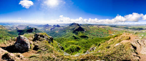
Panoramic view showing houses, mountain ranges and sugar cane plantation
The island of Mauritius is situated some 2,000 kilometers (1242 miles) off the south east coast of the African continent, between Latitudes 19°58.8′ and 20°31.7′ South and Longitudes 57°18.0’and 57°46.5′ East, it is 65 km long and 45 km wide, its land area is 1,864.8 km2. Mauritius is surrounded by more than 150 kilometers (93 miles) of white sandy beaches and the lagoons are protected from the open sea by the world’s third largest coral reef, which surrounds the island. Just off the Mauritian coast lie some 49 uninhabited islands and islets; some of them are used as natural reserves for the protection of endangered species.
Environment
The environment in Mauritius is typically tropical in the coastal regions with forests in the mountainous areas. Mauritius ranked second in an air quality index released by the World Health Organization in 2011.
Situated near the tropic of Capricorn, Mauritius has a tropical climate. There are 2 seasons: a warm humid summer from November to April, with a mean temperature of 24.7° and a relatively cool dry winter from June to September with a mean temperature of 20.4°. The temperature difference between the seasons is only 4.3°. The warmest months are January and February with average day maximum temperature reaching 29.2° and the coolest months are July and August when average night minimum temperatures drops down to 16.4°. Annual rainfall ranges from 900 mm on the coast to 1,500 mm on the central plateau. Although there is no marked rainy season, most of the rainfall occurs in summer months. Sea temperature in the lagoon varies from 22° to 27°. The central plateau is much cooler than the surrounding coastal areas and can experience as much as double the rainfall. The prevailing trade winds keep the East side of the island cooler and also tend to bring more rain. There can also be a marked difference in temperature and rainfall from one side of the island to the other.
Districts
Mauritius is divided into nine districts, which consist of different cities, towns and villages. The island of Rodriguez used to be the country’s tenth district before it gained autonomous status in 2002.